
Wheat Ridge development goes to Great Falls planning board this week
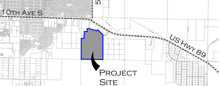

The city planning board will consider Tuesday the annexation of 20.98 acres for the proposed Wheat Ridge Estates behind the Wal-Mart on 10th Avenue South.
The board will also consider a Planned Unit Development zoning and the preliminary plat for the project.
City staff is recommending denial of the annexation, zoning and preliminary plat.
City staff recommending denial of Wheat Ridge annexation, zoning
The 20.98 parcel requested for annexation is part of a much larger 227.63 acre property owner by the KYSO Corporation.
Under state law, annexation is discretionary and not mandatory. The city is able to weigh each application on its individual merits as they relate to the city’s interest and can deny an application if those merits don’t support annexation, according to the staff report.
The property is bordered by Walmart and vacant commercially zoned property to the north, the KOA Campground and vacant property to the west, and vacant property to the south and east.
The northeast portion of the 227.63 acre property adjoining U.S. Highway 89 and Malmstrom Air Force Base contains a 10.21 acre Airfield Restrictive Easement not being disturbed for development.
The easement decreases the total potential development area of the larger parcel to 217.42 acres. The entire parcel is located within the Cascade County Planning Jurisdiction and zoned Agricultural, which restricts development to single family detached units or two-unit dwellings on parcels that must be at least 20 acres in size.
The applicant filed a Certificate of Survey with the county to divide off the 20.98 acre parcel through an agricultural exemption to the county’s subdivision ordinance. Since the 20.98 acre parcel is adjacent to the city limits, it is eligible for annexation consideration.
The property is currently owned by KYSO Corporation, or Dan Huesits, and the housing development is being proposed by Spencer Woith and his team.
Woith has been planning since 2005 to develop the property as a master planned community that would include different housing types, some mixed use properties for residential and commercial uses, as well as pocket parks and linear greenways.
The mix of uses is the reason the applicants have requested a PUD zoning.
Woith previously developed the Berkner Heights residential subdivision as well as the East Ridge residential subdivision in the southeast portion of the community. But no development proposal had moved forward for public hearing review until this year.
The proposal for the first phase, which is the 20.98 acres, includes subdivision to create three mixed-use lots and 37 single family detached home lots.

Conceptual plans for the larger Wheat Ridge master plan area.
Since the project was noticed with signs on the property, published notices and media coverage, staff has not received any contacts for information or comments supporting or opposing the proposal.
The project was presented by the applicant at a Neighborhood Council 5 meeting on Feb. 19 and the council voted to support the project.
City staff and Malmstrom officials have expressed a number of concerns related to the Wheat Ridge proposal.
Great Falls Fire Rescue has concerns about response times and access to the parcel since the current proposal shows only a single public street access. The 2012 International Fire Code, which the city adopted, requires two separate and approved fire apparatus access roads when the number of dwelling units exceeds 30.
KYSO and Woith have begun the permit process with the Montana Department of Transportation to get an emergency access approach onto Highway 89. They haven’t formally incorporated the emergency access into the proposed flight plan and GFFR would require that it be paved.
Stormwater management is also a concern for the city since there are already stormwater issues in the area. The city is involved in litigation over stormwater drainage and groundwater impacts from previous developments in the area that were annexed into the city. The plaintiff in that case, L. Johnson Inc., owns property bordering the Wheat Ridge master plan area on the southern end.
The city engineering department has recommended that Phase I stormwater for Wheat Ridge either be retained completely through a lined pond or pumped into the next drainage basin to the north, but the applicant doesn’t favor either approach.
“This is a difficult issue, and one the Board should understand prior to considering annexation and higher density development,” staff wrote in their agenda report.
Conflict with existing operations at Malmstrom are also a concern. The runway was deactivated in 1997 and since then discussions have continued over how to protect future missions for the base while still allowing development.
The Air Force told The Electric that it has no plans to reactivate the runway, though the 120th Airlift Wing is using the area for drop training and has been working to develop an assault landing strip on base.
The 2012 Joint Land Use Study conducted by the city, county and Malmstrom puts 89 percent of the larger parcel within Accident Potential Zone I, according to the staff report. About 30 percent of the 20.98 acre parcel is in the APZ.

According to the JLUS, compatible uses in the area include agricultural; open space; commercial when not within a designated military safety zone and buildings and structures are below a specified building height; some industrial because industrial uses have many of the same characteristics as military uses such as noise, dust, steam, smoke, safety, etc.
Incompatible uses near the base, as identified by the JLUS, include medium to high density residential, because high numbers of people are permanently congregated in small areas; schools; childcare centers; assisted living complexes; public institutions; office buildings.
In a memo from Malmstrom, officials write that residential/commercial development on the undeveloped lands southwest of the base could impact operations.
Among the areas that could be impacted: 110-acre helicopter movement area; 625-acre drop zone; 4,800 foot long by 60 foot wide proposed assault landing zone.
Usage in the area includes 1,232 flight orders per year and 1,696 sorties per year; 42 functional check flights per year for the UH-1N Huey helicopter operations. According to the memo, the flight hours have increased by 25 percent for fiscal year 2018 from 3,200 hours to 4,000 hours. For the C-130 operations, there are 500 training bundles/sandbags and 500 heavy drops annually, as well as 500 projected sorties per year if the assault landing zone is constructed.
According to Malmstrom’s memo, development could impact multiple arrival and departure flight tracks for the Hueys and light pollution from the development could impair the ability to monitor aircraft in formation during night operations.
Hueys fly about 500 feet above ground level in the area of the proposed Wheat Ridge and aircraft noise could pose a nuisance to the area, according to the memo.
City staff has advised the developers to proactively identify proper noise mitigation techniques into construction design for the development, but according to staff, the applicant has not yet addressed the issue in its annexation petition.
Other issues include street naming since the developer is proposing to extend 57th Street South but call it “Wheat Ridge Parkway,” which is inconsistent with the city’s street naming policy. The proposal also indicates a large median for the extended 57th Street but the city Park and Recreation Department has indicated they do not have the staff or resources to maintain the medians. The developers have proposed that the medians be maintained by a homeowners association.
The city streets division is concerned about the medians as they complicate snow removal operations.


Pingback: City planning board votes to postpone Wheat Ridge decision | The Electric